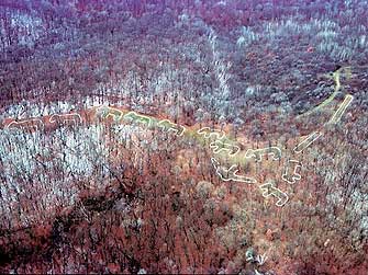
 Figure 1. Aerial view of effigies located at Effigy Mound National Monument.
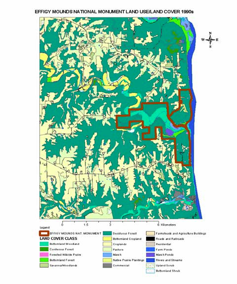
Figure 2. Land use/land cover at Effigy Mounds National Monument
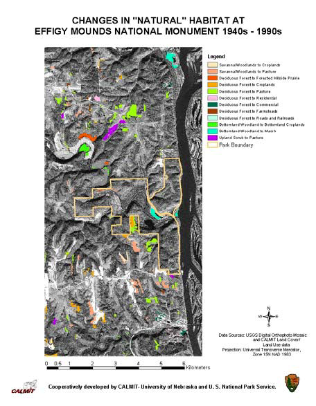
Figure 3. Changes in land use/land cover at Effigy Mounds National Monument from the 1940s to the 1990s.
Background: Three historical parks in the mid-western United States, Effigy Mounds National Monument (EFMO), northeastern Iowa, Wilson’s Creek National Battlefield (WICR), southwestern Missouri, and Pipestone National Monument (PIPE), southwestern Minnesota are faced with the pressure of anthropological changes in the landscape surrounding them. The issue of how to manage the landscape of a U S National Monument dedicated to preserving a historical theme is the focus of this study. The U S National Park Service is collaborating with UNL-CALMIT to document land use/land cover changes in these parks during the last 60 years to facilitate management decisions for the protection of America’s heritage.
The study area comprises of Effigy Mounds National Monument (EFMO) which covers approximately 1,618 hectares. It is located in the plains area of northeastern Iowa adjacent to the Mississippi River. The parks have 195 prehistoric mounds constructed in the shape of mammals, birds, and reptiles or are conical, linear and compound, and forms part of the Native American culture. Natural vegetation comprises of forests, tall grass prairie, and wetlands. The Mississippi River forms the eastern boundary of the park. This research also extended around a 5-km radius outside of the park boundary. Land cover within this buffer is similar to that found within the park; however, it includes substantial areas of agricultural and rangeland.
Methods: Land use/land cover was derived by visually interpreting IKONOS pan-sharpened satellite imagery, acquired in October 2000. IKONOS is a commercial satellite launched by Space Imaging. Its sensors are capable of acquiring data in multispectral (4-bands: blue, green, red, near-infrared) at 4×4 m spatial resolution and panchromatic (spatial resolution = 1×1 m) modes. The pan-sharpened data were produced by Space Imaging by merging the multispectral and panchromatic bands and applying a bi-cubic interpolation algorithm for a smooth visual appearance. Black-and-white digital orthophoto quadrangles (DOQs; 1×1 m resolution) were used to aid in the interpretation. DOQs are produced by the USGS from standard aerial photographs with relief displacement removed, so that the features on the ground appear in their correct geographic location.
A vegetation classification for EFMO was developed from the National Vegetation Classification System (NVCS), the USGS Land Use Land Cover Classification (Anderson, 1976), and information derived from work in progress by USGS Midwest Environmental Sciences Center (USGS-MESC; Table 1). Land use/land cover polygons were derived by manual digitizing of the pan-sharpened IKONOS and the DOQ data. Attributes were assigned based on the vegetation classification scheme. Ancillary data from United States Fish and Wildlife Service (USFW) National Wetlands Inventory (NWI), USGS digital elevation models (DEM), USDA soil profiles, NPS digital line graph (DLG) information was used to provide information about possible routes of invasion for species of plants and animals detrimental to the ecology of the small parks. Additional data sets compiled from Multi-Resolution Land Characterization 2000 (USGS, 2000) were manipulated to subsets for a regional 80-kilometer buffer map depicting LULC at a 30×30 m resolution and including geo-referenced protected habitats that could serve as genetic resource pools.
Results
Land Cover interpretation and analysis for the EFMO shows that 50% of the study area is covered by deciduous forest (Table 2). However, nearly 35% of the land area is represented by cropland and pasture, thus signifying the impact of anthropogenic activities within the region. An important assessment of the landscape includes the mean patch size. It should be noted that deciduous forests in this study area exist in rather large sizes (mean patch size being 118 ha). This would be important from the perspective of those animal species that require large and contiguous sustenance habitat. However, the variability in the patch sizes (based on the standard deviation) indicates that there are considerable differences in the size and contiguity of the forested lands.
Conclusions
This research provides the preliminary results for an ongoing study of the Prairie Cluster LTEMs to support their goals for change detection studies of EFMO and two other parks (Pipestone in Minnesota, and Wilson’s Creek Battlefield in Missouri). Aerial photography for the 1940s and 1960s will be used to evaluate the change over a 60-year period. Advanced landscape metrics will be derived to assess direct loss of natural habitat, habitat alteration in and around the LTEM sites, spatial location of rapidly developing areas, and invasion corridors for exotic species. Temporal analyses will also provide information on how the changes over six decades will affect the regenerative capabilities of native species. In addition, the 80-km coarser resolution maps will provide a regional perspective of the spatial extent, distribution, and connectivity of natural areas, and allow consideration of how the Prairie Cluster parks fit into regional landscape dynamics.
Funding for this project has been provided by the United States National Park Service through the Prairie Cluster Long Term Ecological Monitoring Program (LTEM).